![](/images/other/stat-length.png)
![Tour Mountainbike Gouffern en Auge - Randonnée VTT - Le Bourg Saint Léonard - Photo](https://media.geolcdn.com/t/1900/400/ext.pjpeg?maxdim=2&url=https%3A%2F%2Fservices.sitytrail.com%2FGeolivesWS%2FDownloadMedia.ashx%3FTrailID%3D214869%26Media%3D15415_1.jpg)
Randonnée VTT - Le Bourg Saint Léonard
tracegps
Benutzer
![Länge](/images/other/stat-length.png)
Länge
43 km
![Maximale Höhe](https://static1.geolcdn.com/siteimages/upload/files/1508320355ic_sort_altitude_max_24dp.png)
Maximale Höhe
259 m
![Positive Höhendifferenz](https://static1.geolcdn.com/siteimages/upload/files/1508320355ic_sort_den_pos_24dp.png)
Positive Höhendifferenz
754 m
![Km-Effort](/images/other/stat-length.png)
Km-Effort
53 km
![Min. Höhe](https://static1.geolcdn.com/siteimages/upload/files/1508320355ic_sort_altitude_min_24dp.png)
Min. Höhe
105 m
![Negative Höhendifferenz](https://static1.geolcdn.com/siteimages/upload/files/1508320355ic_sort_den_neg_24dp.png)
Negative Höhendifferenz
755 m
![Boucle](https://static1.geolcdn.com/siteimages/upload/files/16400158638029165_repeat_loop_refresh_sync_direction_icon.png)
Boucle
Ja
Erstellungsdatum :
2014-12-10 00:00:00.0
Letzte Änderung :
2014-12-10 00:00:00.0
![Mountainbike](https://static1.geolcdn.com/sitytour/trail-icons/202.png)
2h30
Schwierigkeit : Schwierig
![Scannen Sie diesen QR-Code, um die Tour in der SityTrail-Anwendung zu öffnen](https://capi.geolives.com/qq0zvz2zws4bq2lad0pu/sitytour/trails/214869/qr.png?size=200)
Kostenlosegpshiking-Anwendung
Über SityTrail
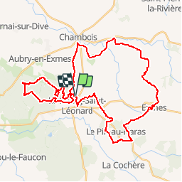
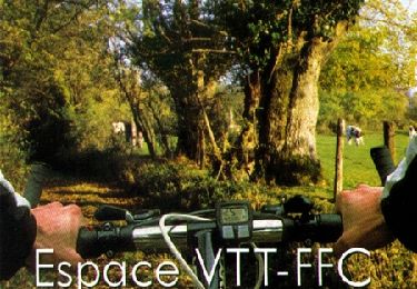
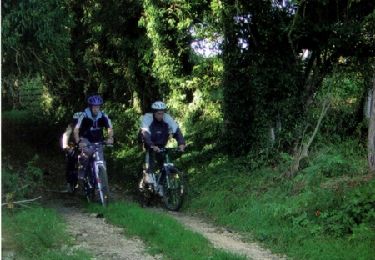
Tour Mountainbike von 43 km verfügbar auf Normandie, Orne, Gouffern en Auge. Diese Tour wird von tracegps vorgeschlagen.
Beschreibung
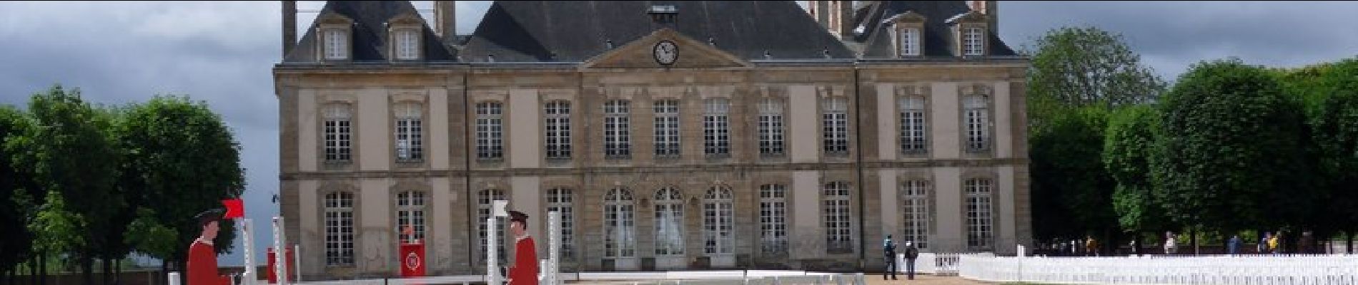
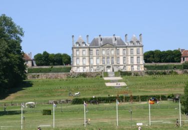
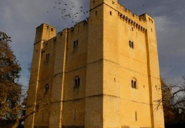
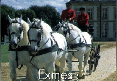
Un circuit d'environ 43 km qui permet de découvrir par les chemins les alentours du Bourg Saint Léonard. Avec notamment une visite de Exmes et du Haras du Pin.
Ort
Land:
France
Region :
Normandie
Abteilung/Provinz :
Orne
Kommune :
Gouffern en Auge
Standort:
Le Bourg-Saint-Léonard
Gehen Sie:(Dec)
Gehen Sie:(UTM)
287175 ; 5405658 (31U) N.
Kommentare
Touren in der Umgebung
![Tour Pferd Gouffern en Auge - Boucle du Bourg-St-Leonard - Photo](https://media.geolcdn.com/t/375/260/ext.jpg?maxdim=2&url=https%3A%2F%2Fservices.sitytrail.com%2FGeolivesWS%2FDownloadMedia.ashx%3FTrailID%3D112044%26Media%3D9572_2.jpg)
![Pferd Pferd](https://static1.geolcdn.com/sitytour/trail-icons/300.png)
Boucle du Bourg-St-Leonard
Pferd
Schwierig
Gouffern en Auge,
Normandie,
Orne,
France
![](/images/other/stat-length.png)
20 km | 23 km-effort
5h 0min
![](https://static1.geolcdn.com/siteimages/upload/files/16400158638029165_repeat_loop_refresh_sync_direction_icon.png)
Ja
![Tour Wandern Le Pin-au-Haras - Versailles du cheval - Le Pin au Haras - Photo](https://media.geolcdn.com/t/375/260/ext.jpg?maxdim=2&url=https%3A%2F%2Fservices.sitytrail.com%2FGeolivesWS%2FDownloadMedia.ashx%3FTrailID%3D111666%26Media%3D7904_2.jpg)
![Wandern Wandern](https://static1.geolcdn.com/sitytour/trail-icons/101.png)
Versailles du cheval - Le Pin au Haras
Wandern
Medium
Le Pin-au-Haras,
Normandie,
Orne,
France
![](/images/other/stat-length.png)
6,9 km | 8,4 km-effort
2h 19min
![](https://static1.geolcdn.com/siteimages/upload/files/16400158638029165_repeat_loop_refresh_sync_direction_icon.png)
Ja
![Tour Pferd Gouffern en Auge - Août 1944 - Chambois - Photo](https://media.geolcdn.com/t/375/260/ext.jpg?maxdim=2&url=https%3A%2F%2Fservices.sitytrail.com%2FGeolivesWS%2FDownloadMedia.ashx%3FTrailID%3D111645%26Media%3D7887_2.jpg)
![Pferd Pferd](https://static1.geolcdn.com/sitytour/trail-icons/300.png)
Août 1944 - Chambois
Pferd
Medium
Gouffern en Auge,
Normandie,
Orne,
France
![](/images/other/stat-length.png)
16,1 km | 19 km-effort
4h 0min
![](https://static1.geolcdn.com/siteimages/upload/files/16400158638029165_repeat_loop_refresh_sync_direction_icon.png)
Ja
![Tour Mountainbike Gouffern en Auge - Août 1944 - Chambois - Photo](https://media.geolcdn.com/t/375/260/ext.jpg?maxdim=2&url=https%3A%2F%2Fservices.sitytrail.com%2FGeolivesWS%2FDownloadMedia.ashx%3FTrailID%3D111644%26Media%3D7887_2.jpg)
![Mountainbike Mountainbike](https://static1.geolcdn.com/sitytour/trail-icons/202.png)
Août 1944 - Chambois
Mountainbike
Medium
Gouffern en Auge,
Normandie,
Orne,
France
![](/images/other/stat-length.png)
16,1 km | 19 km-effort
1h 30min
![](https://static1.geolcdn.com/siteimages/upload/files/16400158638029165_repeat_loop_refresh_sync_direction_icon.png)
Ja
![Tour Wandern Gouffern en Auge - Août 1944 - Chambois - Photo](https://media.geolcdn.com/t/375/260/ext.jpg?maxdim=2&url=https%3A%2F%2Fservices.sitytrail.com%2FGeolivesWS%2FDownloadMedia.ashx%3FTrailID%3D111643%26Media%3D7887_2.jpg)
![Wandern Wandern](https://static1.geolcdn.com/sitytour/trail-icons/101.png)
Août 1944 - Chambois
Wandern
Schwierig
Gouffern en Auge,
Normandie,
Orne,
France
![](/images/other/stat-length.png)
16,1 km | 19 km-effort
5h 0min
![](https://static1.geolcdn.com/siteimages/upload/files/16400158638029165_repeat_loop_refresh_sync_direction_icon.png)
Ja
![Tour Mountainbike Gouffern en Auge - Espace VTT FFC du Pays d'Auge Ornais - Circuit n°14 - Trans'Pays d'Auge - Photo](https://media.geolcdn.com/t/375/260/ext.jpg?maxdim=2&url=https%3A%2F%2Fservices.sitytrail.com%2FGeolivesWS%2FDownloadMedia.ashx%3FTrailID%3D102042%26Media%3D2363_2.jpg)
![Mountainbike Mountainbike](https://static1.geolcdn.com/sitytour/trail-icons/202.png)
Espace VTT FFC du Pays d'Auge Ornais - Circuit n°14 - Trans'Pays d'Auge
Mountainbike
Schwierig
Gouffern en Auge,
Normandie,
Orne,
France
![](/images/other/stat-length.png)
20 km | 26 km-effort
1h 30min
![](https://static1.geolcdn.com/siteimages/upload/files/16400158638029165_repeat_loop_refresh_sync_direction_icon.png)
Nein
![Tour Mountainbike Gouffern en Auge - Espace VTT FFC du Pays d'Auge Ornais - Circuit n°12 - Exmes - Photo](https://media.geolcdn.com/t/375/260/ext.jpg?maxdim=2&url=https%3A%2F%2Fservices.sitytrail.com%2FGeolivesWS%2FDownloadMedia.ashx%3FTrailID%3D102041%26Media%3D2362_1.jpg)
![Mountainbike Mountainbike](https://static1.geolcdn.com/sitytour/trail-icons/202.png)
Espace VTT FFC du Pays d'Auge Ornais - Circuit n°12 - Exmes
Mountainbike
Schwierig
Gouffern en Auge,
Normandie,
Orne,
France
![](/images/other/stat-length.png)
24 km | 28 km-effort
2h 0min
![](https://static1.geolcdn.com/siteimages/upload/files/16400158638029165_repeat_loop_refresh_sync_direction_icon.png)
Ja
![Tour Mountainbike Gouffern en Auge - Espace VTT FFC du Pays d'Auge Ornais - Circuit n°4 - Trun - Photo](https://media.geolcdn.com/t/375/260/ext.jpg?maxdim=2&url=https%3A%2F%2Fservices.sitytrail.com%2FGeolivesWS%2FDownloadMedia.ashx%3FTrailID%3D102038%26Media%3D2359_2.jpg)
![Mountainbike Mountainbike](https://static1.geolcdn.com/sitytour/trail-icons/202.png)
Espace VTT FFC du Pays d'Auge Ornais - Circuit n°4 - Trun
Mountainbike
Schwierig
Gouffern en Auge,
Normandie,
Orne,
France
![](/images/other/stat-length.png)
47 km | 53 km-effort
3h 30min
![](https://static1.geolcdn.com/siteimages/upload/files/16400158638029165_repeat_loop_refresh_sync_direction_icon.png)
Ja
![Tour Mountainbike Gouffern en Auge - Espace VTT FFC du Pays d'Auge Ornais- Circuit n°3 - Chambois - Fel - Photo](https://media.geolcdn.com/t/375/260/ext.jpg?maxdim=2&url=https%3A%2F%2Fservices.sitytrail.com%2FGeolivesWS%2FDownloadMedia.ashx%3FTrailID%3D102037%26Media%3D2358_1.jpg)
![Mountainbike Mountainbike](https://static1.geolcdn.com/sitytour/trail-icons/202.png)
Espace VTT FFC du Pays d'Auge Ornais- Circuit n°3 - Chambois - Fel
Mountainbike
Medium
Gouffern en Auge,
Normandie,
Orne,
France
![](/images/other/stat-length.png)
8 km | 9,1 km-effort
40min
![](https://static1.geolcdn.com/siteimages/upload/files/16400158638029165_repeat_loop_refresh_sync_direction_icon.png)
Ja
tres bien